![]() INDIA
TREKKING NANDA DEVI TRAVELS AND TOURS PACKAGES FOR NANDADEVI
INDIA
TREKKING NANDA DEVI TRAVELS AND TOURS PACKAGES FOR NANDADEVI
Information on Nandadevi trekking, Nandadevi tours, Nanda Devi National Park tours, Nanda Devi trekking tours, India Nanda Devi tours, Nanda Devi trekking
|
"We do not Experiment, We Excel with Experience"
Trekking Himalaya
|
The Himalayan Adventures is all about giving you the best travel experience coupled with just the right amount of activity and scenic beauty to get your adrenaline pumping...and that isn't just because of hiking, trekking or white water rafting...the mighty mountains have more than spine tingling adventures, take a look at the beautiful views it has in store for you.
The Himalayan Adventures invites the ecologically-conscious traveler to experience the world of nature, to help create a sustainable model for eco-tourism and adventures, and to support wild land that have been preserved, and help preserve those that are still in danger.
![]() Adventure Tours In
Indian Himalayas
Adventure Tours In
Indian Himalayas
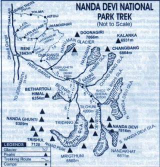
Nanda Devi
National Park ( World Heritage Site)
Nanda
Devi National Park, which is Paradise on Earth, is located in the northern
part of the west Himalayas. The reserve is spread over Chamoli district in
Garhwal region. The credit of first known attempt to enter the inner basin
of Nanda Devi goes to W.M Graham in 1883, followed by Dr.T.G. Longstaff
(in 1907) and later by Hugh Rutledge in 1926,27 and 1934 Eric 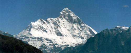 Shipton and
W.Tilman ultimately forget their way through the steep
Shipton and
W.Tilman ultimately forget their way through the steep
|
Introduction |
and narrow Rishi Gorge to the inner
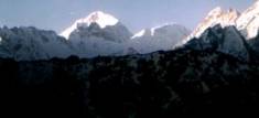
basin in1936. The spectacular panorama of peaks encircling the National
Park are Dunagiri (7066mt), Changbang (6864mts), Kalnka(6931mts), Rishi
Pahar (6992mts), Mangraon (6765mts), Maiktoli (6803mts), Mrigthuni
(6655mts), Trishul I (7120mts) , Trishul II (6319mts), Beathertoli Himal
(6352mts),Nanda Devi East (7434mts), Nand Devi main (7817mts),Devisthan I
(6529 mts), Devisthan II (6678mts) and Hanuman (6070mts) peaks are
situated inside the park.The park is in the form of a cup with lush green
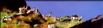
meadows, cluttering white water falls and rich wild flora and fauna. Herds
of blue mountain goats (Bharal) graze everywhere. Sir Edmund Hillary in
his autobiography described the ruggedness of this sanctuary so "Nanda
Devi Sanctuary is God-gifted wilderness -- India's training ground for
adventure..." In 1982,access to trekkers into the Nanda Devi National
Park was banned to protect of biodiversity. The National Park which has
been declared a "World Heritage Site" has been partially opened
recently for tourist exclusive. The beauty of the country side, flora and
fauna and life style of the people of NDBR is best and unforgettable
experience for a meander through lush green hills and dales. No doubt NDBR
with it's snow clad mountains is the perfect destination for vacationers
in quest of enchantment, tranquility or Adventure. We offers a holiday
that is more than a dream - a voyage of adventure and discovery.
OUR TREK ROUTE
The entire trek goes through thick forests and alpine meadows surrounded
by glacial torrents, water falls, hillocky and colorful boulders,
moraines, steep gorges, overhanging cliffs and roaring rivers.
DAY 1 :
RISHIKESH : JOSHIMATH : DRIVE 8/9 HRS : OVERNIGHT : HOTEL
Morning after breakfast drive to Joshimath. The
entire drive toady is along the Ganga and Alaknanda River. We stop at
Devprayag to visit the confluence at the beginning of the Ganges. Arrive
Joshimath and transfer to hotel. Eveing visit the hill town. Dinner and
overnight hotel.
DAY 2 : JOSHIMATH : Day for obtaining
final permission to venture into NDNP from forest authorities, Joshimath.
Overnight Hotel.
Day 3: JOSHIMATH - BELTA : DRIVE 2 HRS : TREK 3
HRS : OVERNIGHT CAMP.
Drive to Lata (a small village at the altitude of 2317 m.) : 26
km on the Joshimath -Malari motor road + 4 km trek to Belta. Duration 2 to
4 hours (up to altitude 2850 m.).
 Day 4: BELTA - LATAKHARAK: TREK 4 - 5 HRS :
OVERNIGHT CAMP.
Day 4: BELTA - LATAKHARAK: TREK 4 - 5 HRS :
OVERNIGHT CAMP.5 km from Belta. Duration 3 to 5 hours (altitude 3689 m.).
The trek starts in the early morning to Lata Kharak; it is a steep trek, through dense forest. A forest hut is available there.From Lata Kharak one can see the Chaukhamba Peaks & its range, Neelkanth Peak & Nar /Narayan Peak, Mana Peak & its range, Hathi Ghodi Parwat, Barhmal peak, the Kuaripass area and the Dayari Sera.
Mostly Lata Kharak is famous for the Nanda Peaks such as Ronthi & Nanda Ghunti, Bethartoli, Nanda Khat & many other Nanda peaks. All these peaks are seen very near at Lata Kharak.
Lata village, Tapovan, Dhak & Bhavisya Badri are easily seen from here.
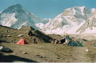
Day 5: LATA KHARAK - DHARASSI PASS : TREK 5-6 HRS : OVERNIGHT CAMP.
8 km trek from Lata Kharak (altitude at top 4665 m.). Duration 5 to 7 hours.
From Satkula to Dharassi pass is steep and rocky. One can have difficulties after 2 km trek from Satkula when the rocky surface begins to enter the pass: some equipment brought by the guide and porters shall be needed to face these types of difficulty.
The Pass appears to be a long steep trek with many ascents and descents until the Nanda Devi comes into the view when crossing the Pass. Dharassi Pass is a Camp side where water is available. The Pass is near by a green grassy meadow, which covers many types of wild animals and birds. There is a beautiful small flat meadow near by Pass from where one can enjoy the Nanda Devi Sanctuary nearly. There are rich flora & fauna inside the Pass.
The Pass beauty is everlasting: the view is over the Nanda Devi, Donagri, Mrigthuni, Mangraon, Changbang, Kalnka, Hanuman and many other peaks are seen from here. The whole Nanda Devi Sanctuary is seen from here. Sir Emund Hillary described the Sanctuary as a God - Gifted.
Day 6: DHARASSI PASS - DIBERUGETHA : TREK 4-5 HRS : OVERNIGHT CAMP.
4 km from Dharassi pass. Duration 2 hours down & 3 hours steep back trek (3500 m.).
Like the inner sanctuary, the prominent Malthuni-Bethartoli ridge, between Dharansi Pass and Debrugheta, also divides the outer sanctuary. Both these ridges from magnificent Pass to Rani Kholi and up to Donidhar is a gradual descent and then from Donidhar to Debrugheta is a steep descent of 750 m till one cross the improvised bridge over the stream. Afternoon return trek to Dharansi Pass. Overnight in tent. If one has luck, he can enjoy the wild animals like black bear, musk deer, Monal pheasant and many other types of wild animals. Dibrugetha is inside a huge dense forest, only one can enjoy streams and wild Flora & Fauna inside the Forest.
Day 7: DHARASSI PASS - TOLMA : TREK 4 -5 HRS : OVERNIGHT CAMP.
Duration 4 to 5 hours (altitude 3750 m.).
Tolma is a nice small village inside a forest, but we are making the camp before the Tolma village. The camp side is a small flat part inside a forest where a beautiful water stream is available. Only Tolma & Suraithota village are seen from here.
Day 8: TOLMA - JOSHIMATH : TREK 2 HRS : DRIVE 2 HRS : OVERNIGHT CAMP.
Ater breakfast 3 kms trek down to Surai Thotha through the rich forest ot Thuner, Kail, Ddevdar and Surai. Then further trek down 3 kms to road head. Drive to Joshimath 30 kms.
DAY 9 : JOSHIMATH : RISHIKESH : DRIVE 8/9 HRS : OVERNIGHT - HOTEL / CAMP.
Possibility of other treks. In Joshimath or trace the step back to Rishikesh.
Contact us for details of the day to day itineraries and cost, or for any program you wish to plan for your holidays in Uttaranchal ( Garhwal & Kumaon ) Himalalayas.